The secret island of the Americas
Epistemic status: Obviously true if you accept what a continent is.
An island or a continent, as we know, is a connected component of land. The distinction between islands and continents is arbitrary: If it’s at least the size of Australia, it’s a continent. It it’s smaller than Australia, it’s an island.
Note that the separation doesn’t have to be by a natural body of water: It’s generally accepted that North and South America are two separate continents, but the body of water separating them is the man-made Panama canal. Similarly Africa is a separate landmass from Eurasia, but only thanks to the Suez canal. Bridges on the other hand don’t count (Lots of islands have bridges to them but are still islands). Basically, it works by the same rules as zombies: You can’t cross over running water without going into a new landmass.
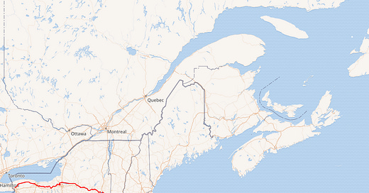
Which brings us to this map of the Erie canal:
As we can see, there’s a huge chunk of “North America - Northeast New York, New England, New Brunswick, Nova Scotia - that’s technically its own separate island1. I propose the name “New America” for this hitherto-undiscovered island.
Finally, let’s try to estimate the land area and population of New America. Its main components are:
New England: about 187k square kilometers and 15 million people.
New Brunswick: 73k square km, 0.8 million people.
Nova Scotia: 55k square km, 1 million people.]
Southern Quebec: This handy Wikipedia page lists the regions of Quebec by area and population. the regions south of the St Lawrence are 1,5,11,12,16, and 17. Their areas are (respectively): 22.2k, 10.2k, 20.3k, 15.1k, 11.1k, and 6.9k. Their populations are 0.20m, 0.34m, 0.09m,0.43m, 1.59m, 0.25m for a sum of about 86k square km and 3m people.
Northeast New York: This one’s the hardest. For area, I’m going to ballpark it by sight and say about 40% of the state’s land area is in New America, for about 56k square km. For population, going by this site and filtering for counties on the island, we get the Bronx, Westchester, Monroe, Onondaga, Dutchess, Saratoga, Oneida, and Niagara out of the top 20, for about 4.6m people. If we assume for the rest of the state, the proportion of the population in New America is roughly distributed as it is for the top 20 counties2, we get about 5.4m people.
So overall, we have an island of about 457k square kilometers and 25 million people, smack down in the middle3 of what was previously thought of as “North America”. This is one of the biggest islands in the world by any measure4 - Going by Wikipedia it would be the 6th biggest island by area (behind Baffin Island but ahead of Sumatra and Honshu) and the 8th largest by population (behind Madagascar and Mindanao5 but ahead of Taiwan and roughly equal to the entire continent of Australia).
There’s a sense these days that American infrastructure is failing and falling behind the rest of the world, as seen by the failure of CAHSR and the boondoggles of New York’s subway extensions. Let us all reflect back on a happier time, when we randomly decided and then successfully created the sixth largest island in the world within eight years, and remember the true glory that American infrastructure projects can achieve when we decide to actually try.
This implies that if there’s ever a zombie outbreak on the mainland, you would be safe in Boston.
This is probably an underestimate - the top counties include most of New York City and Long Island, which are mostly not in New America - but eh, this is all pretty rough anyway.
well off to the side, but you know what I mean
Though interestingly, still only the second biggest island in Canada!
It’s in the Phillipines


Congratulations, you have become an xkcd https://xkcd.com/2838/
I have to point out this old blog post of mine on the same subject :P https://sniffnoy.dreamwidth.org/517574.html (I wasn't counting canals though :P )